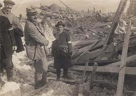
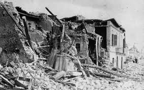
This is not only a true story, but also is timed to mark the 97th Anniversary of the devastating earthquake which destroyed Avezzano on 13th January 1915, resulting in a massive loss of life.
Have you ever been in an earthquake? I have, once, and it’s scary. Not a powerful earthquake, admittedly, and most California residents would probably have called it a tremor. However, it was enough to wake me up in the middle of the night, in the dark, and my first thoughts were Why does it feel like my head is spinning? Did I really drink that much vino rosso with my bistecca di manzo dinner at Umberto’s Ristorante?
Only after turning on the bedside light in the hotel did I realise that it was my head that was spinning, as was the chandelier in the middle of the room. That’s when the fear hit me: I was in the town of Avezzano in the Abruzzi region of the Apennine Mountains in Italy, some 120km east of Rome. That in itself was no cause for concern, but remembering that Avezzano was totally destroyed by an earthquake on January 13th 1915 with only a 4% survival rate had me shooting out of bed, flying down the stairs and out into the street.
I wasn’t the only person exiting the Hotel Principe half-dressed and half-asleep, so maybe it was more than a mere tremor.

Aftermath – Avezzano, 1915

Aftermath – Avezzano, 1915
This happened in the late 1970s while I was working for the European Space Agency (ESA). At that time I was responsible for the in-orbit testing of the transponders of the OTS satellite, and the satellite control & test station (SCTS) was hosted by Telespazio spa at their Fucino earth station complex. Avezzano was the nearest town about 16km northwest and I spent much of a two year period there. Now, before you launch Google Maps here’s one I prepared earlier and I can tell you that the whole area is earthquake prone. If you zoom out two clicks you can see that L’Aquila, site of the 6 April 2009 6.3 magnitude earthquake which killed 300 people and destroyed thousands of buildings, is only some 45km north of Avezzano.
See if you can find the Telespazio earth station complex on the map!
It’s about 11km South East of the map marker.

Telespazio’s Fucino Earth Station
I can’t remember whether I went immediately back into the hotel to grab car keys, shirt and trousers, but it wasn’t long before I set off to drive to the Fucino earth station to see if all was well. I was concerned because the Conca del Fucino used to be a very large lake – in fact in Roman times sea battles involving large ships, sacrificial slaves and gladiators were played out on the lake to entertain the populace and the Emperor of the time. Over the centuries numerous attempts were made to drain the lake (hundreds of slaves were drowned in the early attempts), until eventually the Dutch succeeded and completed the job.
The reason I mention this (fascinating in itself) history is because the pancake-flat Conca del Fucino (now the largest potato growing area in Italy – the patchwork of fields is clearly visible on the Google Map) is made up of silt; to a depth of heaven knows how many metres. Anyone who’s watched Nat Geo or Discovery Channel on TV will know that earthquakes and silt soil do not go well together!
When I arrived at the earth station everything looked normal, so at least the antennas hadn’t disappeared into the depths of liquefaction! I thought I’d better check the telemetry to see how the spacecraft was doing and everything looked normal, including the AOCS (Attitude & Orbit Control System). My next check was the earth station antenna tracking status and this is where a bit of technical background is needed. Don’t get put off, because this is where the story gets interesting.

The OTS-2 Satellite In Orbit – Artist’s Impression

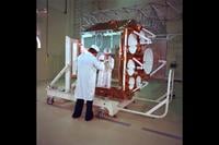
OTS-2 Pre-LaunchTesting
OTS was one of the first 3-axis stabilised geostationary satellites (ATS-6 was the first) and was the first satellite to carry 6 Ku-Band (12/14GHz) transponders. The main SCTS earth station antenna we were using at Fucino was a custom-built 13 metre Cassegrain dish, and AEG Telefunken was the prime contractor. This had a 3dB beamwidth of 0.15 degrees at 11GHz, but we needed a real-time tracking accuracy of much better than +/-0.005 degrees.
There are basically three types of tracking system one can use; program track, step track or monopulse. For a testing application where accuracy is paramount SCTS was equipped with a monopulse system. This technology is used for extremely accurate tracking of fast moving objects, be they missiles or satellites. In essence, it’s an extremely sensitive closed-loop control system so the pointing of the earth station antenna in Az (azimuth) and El (elevation) immediately follows even the slightest movement of the spacecraft.
OK. I looked at the tracking log file for OTS for the previous few hours. The graph of the earth station’s Az & El pointing angles should have been gentle sinusoids of +/-x degrees with a 24 hour period reflecting the satellite’s daily figure-of-eight movement within its 50km cube station-keeping box. What I saw stopped me dead in my tracks; the Az and El plots looked like the output of a seismograph. Both Az and El exhibited massive positive and negative spikes around their nominal values; first one burst of them, then another, then another. Only then did it dawn on me that what I was witnessing wasn’t the satellite movement at all, it was the movement of the antenna’s foundations in the lake-bed silt during the earthquake. The rapid response monopulse tracking system was compensating for the movement of the foundations and was trying to keep the pencil-thin antenna beam locked onto the satellite in its geostationary position some 36,000km above the equator. I had just stumbled upon the ultimate seismograph!
References & Citations
There’s an amazing collection of 34 photos of the aftermath of the 1915 Avezzano earthquake which can be found by a search in the US Geological Survey archive. These were donated by family members of the late Admiral J. Lansing Callan, US Navy Reserve. The monochrome photos above are his.
Courtesy & copyright Telespazio spa for the Fucino earth station photos.
Courtesy & copyright European Space Agency (ESA) for the OTS pictures.


